Sunday 2 December 2012

Kilmuir Cliffs and the Cave of Gold

17th July 2012

The cliffs of Kilmuir are high up on the north west of the Trotternish Peninsula on the Isle of Skye. They are said to be volcanic sills, horizontal undergound lava flows which formed vertical joints as they cooled.


Peering down over the steep gully leading into the Cave of Gold.


The Cave of Gold, with a bloody glow reminiscent of its birth from red hot magma fifty eight million years ago.


More magmatic columns ....


..... some providing homes for itinerant ex-dinosaurs.


Closer to the water the volcanic sill has been partly eroded away by wave energy, giving us a cross sectional view of the columns formed during cooling, in this case with a square outline.


Now the cross sections are oblong, with a basaltic darkness.


 And these are trendng towards the hexagonal.


 Sea stacks; laval columns awaiting downfall through the perpetual tickle of waves, nudging of wind, and bear hug of gravity.
  

I'm not totally convinced that these hugely vertical structures are really the result of horizontal underground intrusions of magma but it was a great day out, despite the absence of giant cabbage leaves.

Monday 10 September 2012

Sheena's pretty rocks day

Five of us went in search of "some really nice rocks" at Glenelg on 5th June 2012.

Looking eastward from the Isle of Skye across Kyle Rhea to the beach at Bernera, near Glenelg on the Scottish mainland.


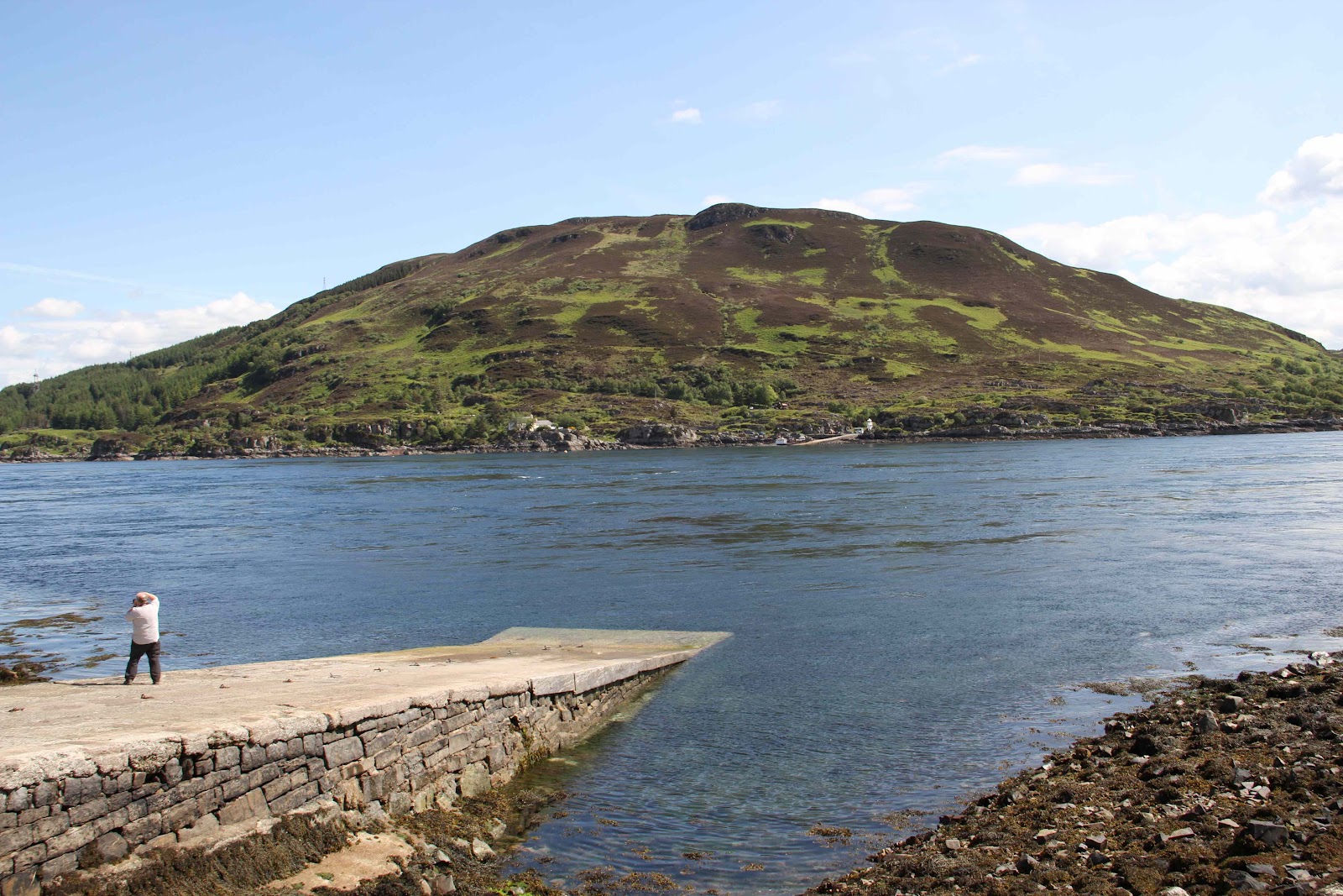
Looking across Kyle Rhea at the crossing of the Glenelg ferry. There's a very rapid current here.


The wee ferry on its way


Looking back at the granite intrusions on Skye


The estuary of the River Glenmore


And so to the rocks on the pebbly beach at Glenelg.

An igneous rock with iron-containing minerals


To me this looks like layers of marble (with a pink mineral) in a grey sedimentary rock. This might be true if it's possible that limestone can leach into crevices in sedimentary rocks or is an actual sedimentary layer itself, and that the pressure (and associated heat) created by subsequently accumulating sedimentary layers is sufficient to convert the limestone to marble. It's more likely perhaps that the marble (if it is marble - I think Jo suggested it was something else) was created through heat transmitted from an adjacent igneous intrusion, which would mean that the grey rock, in spite of its layered appearance, is igneous. From the platform of almost total ignorance one can speculate almost indefintely and equally fruitlessly about the most trivial of geological observations. But therein lies the fun and the frustration. Judy has since stated that the seams in this and the following image comprise quartz, formed from the oxidation of silica-containing solutions.


More of the same. What I don't understand is how one can get layers of marble within igneous rocks. One would imagine that the marble is formed in bulk at the aureole (zone of heat transference) around the igneous intrusion, though perhaps in this region there is some interpenetration of the magma and limestone.


Speculations invited


The orange material is lichen but the pink is a mineral.


A closer look at the pink-red mineral which has been allocated a variety of speculative identifications by members of the group, with Jo proposing biotite and Faye stilbite.


 Perusing pebbles


Many of the pebbles were coated with tiny particle of shiny material, moreso than the one above. Faye says the material is mica.


Same pebble


Looks like a conglomerate


On the way back, looking north east over the eastern end of Loch Duich, we spy the Giant's Hand, which I think is substantially bigger than Jo's Lion.

Thursday 30 August 2012

U3A Geology group sets out for Glen Brittle but finishes up at Talisker Bay

On 4th April 2012 four of us met at Carbost with the intention of travelling to Glen Brittle to check out signs of glaciation. I don't really remember why that didn't happen and why we suddenly found ourselves on the road to Talisker Bay. Perhaps it was another case of alien possession. We had been to Talisker Bay before in a failed attempt to find the ropey lava, so maybe there was also some sort of subconscious unresolved karmic resonance going on. Anhow, we failed once again as no one had thought to ask what the tide might be doing. It was in and the road to the holy grail was blocked.

Dithering


Ignominious retreat


Water eroding basalt cliff through eons of time.


 No one knew what this was.


Perhaps at low tide it would be possible to get a closer look at the red mineral. Do the horizontal cracks in the upper part of the cliff delineate separate lava flows, each approximately 5 meters deep?


Preshal Mor, which could be a volcanic plug or a lava lake; probably the latter as I don't think there were any volcanos in this area. There appear to be 2 sections, the lower one comprising basalt columns, formed as extruded lava cooled relatively rapidly, giving rise to cooling joints perpendicualr to the surface of the flow, and the upper one seemingly diffuse. 
There are some marvellous images of hexagonal rock columns on the twin hill Preshal Beg at the link below. Maybe if we ever go to Talisker Bay again we could focus on exploring the slopes of Preshal Mor?


Wednesday 28 March 2012

The Mystery of Glen Uig and Fairy Glen

Jo reckons Glen Uig/Gleann Conain is a wide glacially sculptured valley with its origin higher up in the Trotternish Hills and that is a very plausible theory, but the landscape of Fairy Glen is something else. It bears a strong resemblance to how one might imagine Hobbiton in The Lord of the Rings and there are clear signs that some people do regard this spot as having some form of "preternatural ambience", though geologists would probably use terms such as igneous intrusions and volcanic shrapnel to bury any fanciful thoughts of dwelling places of fairies and pixies who only come out at night.

Glen Uig, at one time bearing a massive glacier westward into Uig Bay.


Looking south across Glen Uig to Fairy Glen, said to be formed from landslides followed by glaciation.


River Conon


Entering Fairy Glen.


Fairy car park


Looking north from Fairy Glen over Glen Uig.


Can you spot Laa-Laa and Tinky Winky?


Notice the Norah Batty-like wrinkly surfaces which Jo attributes to weathering rather than gravity.


Palace of the Fairy King or basalt intrusion.


Trotternish hills look down into the valley.


Icy stream.


A soft iron-rich rock.


Castle Ewen. Note the dark larval layer containing a ribbon of red rock.


Castle Ewen.

Tuesday 20 March 2012

Gneiss time at Point of Sleat

It was a cool and cloudy day for the group's first visit to the Point of Sleat on the southernmost tip of Sleat Peninsula in south east Skye. Most of Skye has a volcanic topography, but Sleat is an exception. I can't begin to explain the complex geology of this area properly but suffice it to say that rocks were layered, with the oldest, Lewisian gneiss, at the bottom, followed by Torridonian sandstone and shale, then Cambrian quartzite and Durness limestone. The 3 major thrust faults Moine, Tarskavaig, and Kishorn messed things about a bit, introducing the metamorphic rock Moine schist and moving gneiss from the basement to the top floor. Some igneous intrusions are thrown in for good measure. Anyhow, it's all beyond me.

Looking south east across the Sound of Sleat to the Scottish mainland.


What was this again?


Shale layered between igneous rock?


A sandstone layer?


Isle of Eigg


More stuff


Is this a layer if Cambrian quartzite or what?


Something was pushing too hard and it got bent.


Falling


Coastal cows


Volcanic plug or lava lake?